
Research question and topic
What forms of space appropriation are visible in the Plano Piloto and in what way can the construct of
planned, produced space create urbanity?
How is space appropriation and urbanity happening in selected
places?
These questions arose when the research about Brasília and its core, the Plano Piloto, started. One of the first
difficulties encountered during the research process was the eurocentric perspective held by the student
researchers regarding the construct of a ‘city’. This had to constantly be kept in mind, since it would otherwise
have compromised a neutral research process.
Theory
The concept of urbanity is diverse and hard to define; a definition based solely on the size of a city (number of
citizens & footprint) is not enough (Wirth 2020). Urbanity can be translated as a cognitive construct; the
collective identity of a place and lifestyles that evolve from it, regardless of whether a city is defined by
administrative standards, or it being just a rural community.
Given this context, the city of Brasília stands out as it is a planned city, the new capital of a rising state,
and a promise to society of better days to come (Stierli 2013). However, the Brasília of today struggles with
uncontrolled growth and spatial segregation, which makes it almost impossible to live a life without a car due to
the planning being based on the separation of social functions (Bezerra et al. 2017). The aspiration to build a
modern capital with new forms of community living and social integration failed, as nowadays many citizens live in
satellite cities up to 50 km away from the city centre, the so-called Plano Piloto (Cafrune 2016). In
contrast to the city development of Brasília, Brazil was one of the first countries to legitimate the Right to the
City in a national law, the Estatuto da Cidade (Mengay and Pricelius 2011), which was issued to stand
against spatial and social segregation.
The urban aspect of a collective identity of a place stands out in Brasília, not only within Brazil, but globally.
People came from all over the country to settle in this new city in the middle of the cerrado, a dry
plateau in
the backcountry, with almost no pre-existing infrastructure. It was designed by Oscar Niemeyer as a symbol of
modern times, to show the evolving modern Brazilian society. Now, two generations later, one might expect to
encounter a version of Brasília as a thriving and inspiring capital, much more than just the administrative heart
of a huge country. However, old metropolitan centres like São Paulo or Rio de Janeiro still define the typical
charisma of the Brazilian city. This does not mean it does not exist in Brasília, but one has to look more
closely, and to always keep in mind the history of Brasília and how society there has formed since the
independence of Brazil (see About
Brasília).
Results and interpretation with theoretical reference
The architect Oscar Niemeyer and Lúcio Costa, the urban planner behind the construction of Brasília wanted to
build an icon of modernity to manifest the evolving Brazilian society of the modern era. The planning of Brasília
was based on the separation of social functions, which at the time was considered to be the most modern way of
living. The modern society - as Niemeyer perceived it - was based on access to modern technology, which at that
time meant to be able to use automobiles without limitation (see About Brasília). The segregation of the
Brazilian
society of today is based on the limited access to functions because of limited means, which can be seen in the
use of public transport by lower income groups and the domination of the informal sector in the Rodoviária
(central bus / metro station) in contrast to the Conjunto Nacional (shopping mall) (see Mobility in Brasília). With the change of global
societies through increased environmental awareness and the breakup
of social norms and values all over the world, Brasília seems like a remnant of the modern times of acceleration
(Williams 2007). The transition to the postmodern era needs yet to be implemented but is bound by the planning of
Niemeyer/Costa. One could say that Brasília as an icon of modernity does not serve the already existing postmodern
society of contemporary Brazil anymore and only fortifies the growing segregation within its society (Kaiser 1987,
Wehrhahn 1998, Struck 2017).
Due to the decentralization of the city by the separation of functions, it is difficult to identify an actual core
of the city within the Plano Piloto. During the research progress, it was decided to envisage the core of
Brasília
to be the tricentre, consisting of the Rodoviária, the Edifício Conic (a cultural, shopping and service
centre)
and the Conjunto Nacional, and to subsequently compare this tricentre with the Vila Planalto neighbourhood. The
following results are based on the interpreted findings resulting from the application of several different
methods used in the fieldwork.
Making urbanity comprehensible is not easy. The concept of the city within the city according to Ungers and
Kolhaas (1977) - describes a polycentric form of organisation, an ‘archipelago‘ of differences so to speak, which
favours urbanity. According to this understanding, today's cities cannot be understood as a whole, but as a
complex structure with many different ‘islands’ which all have different characters. Urbanity thus meets in
condensed form in the ‘islands’. If we apply this concept to Brasília, we can identify various such ‘islands’.
Firstly, the area around the Rodoviária, the Edifício Conic, and the Conjunto Nacional can be identified as a
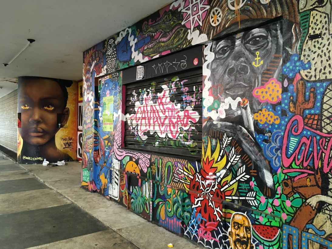
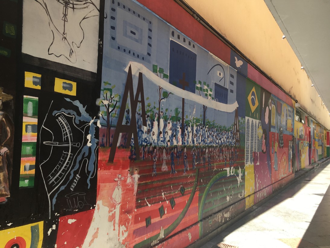
special place for urbanity. In addition, the Vila Planalto neighbourhood is of great relevance considering its
history as a former residential area of construction workers. It is known as one of the most diverse
neighbourhoods in Brasília. This refers to the income differences, the diversity of the residents, as well as that
of the architecture. Urbanity is often associated with diversity, so Vila Planalto is an appealing
neighbourhood
for research. Through the method of strollology/walking (see methods chapter), this
impression was consolidated.
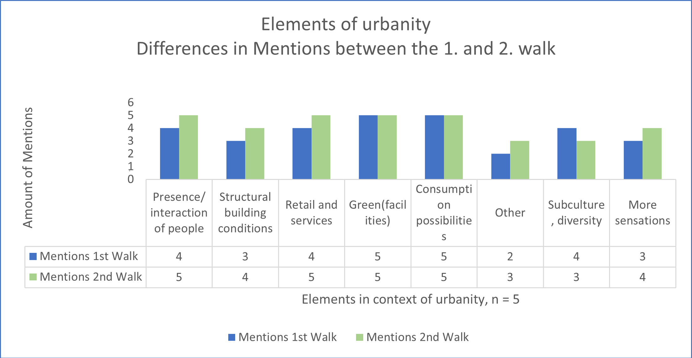
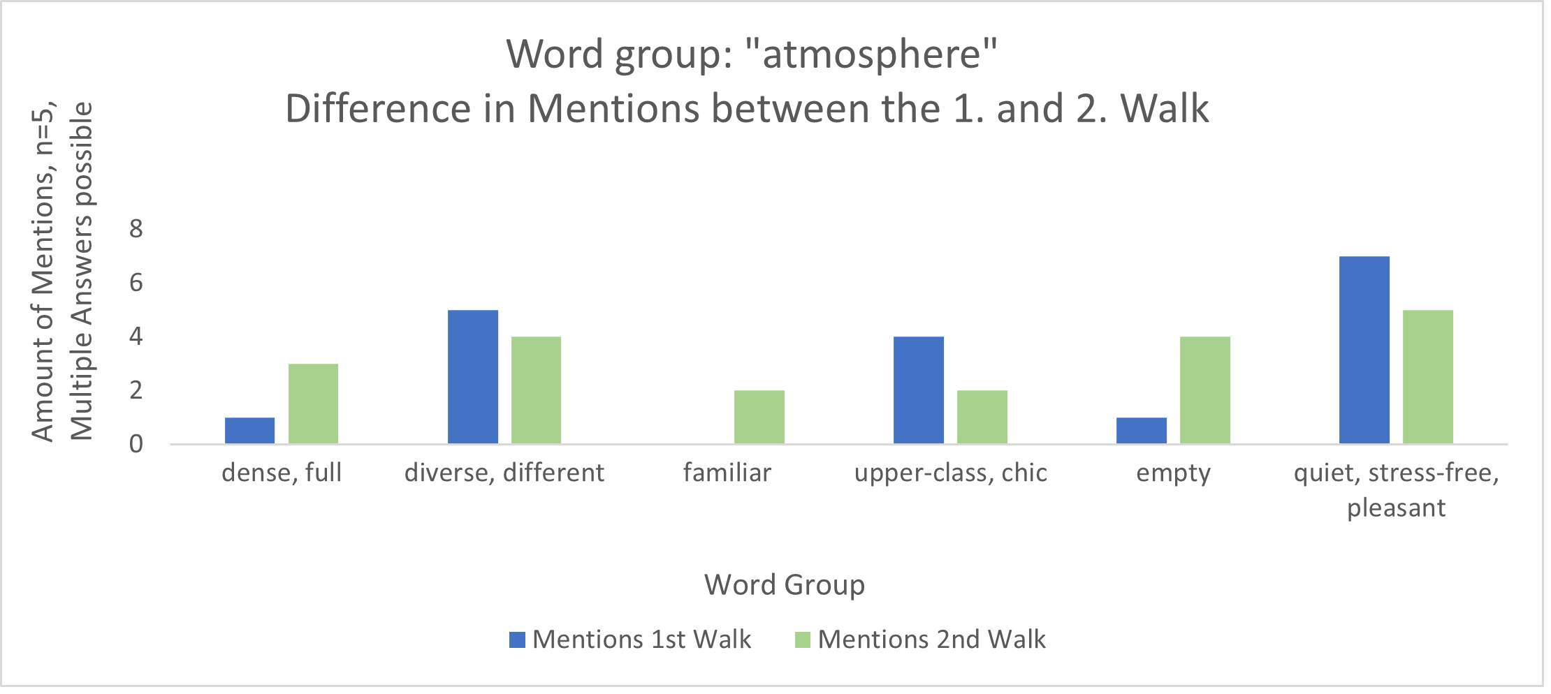
Important aspects of urbanity are human presence and interaction, green spaces and consumption opportunities, as
well as the influence and diversity of subcultures (see diagram). Attributes that were mentioned during the
fieldwork in connection with urbanity were ‘dense/full‘ or ‘diverse/different‘. At the same time, however, Vila
Planalto was also described as ‘familiar, upper-class, and chic‘ as well as ‘quiet, stress-free, and pleasant‘
(see diagram). This discrepancy shows how different the perceptions of the neighbourhood are. In the map, some
photos which were taken during the walks are shown and explained in a wider context.
In summary, Vila Planalto is one of the rare places where the inhabitants successfully fought the planning by the
government. Within the ‘island’ of Vila Planalto, individualism, participation, space appropriation, and
subculture are quite visible, which indicates a vivid urban life. Although different perceptions such as emptiness
or ‘chicness’ underline the diversity and complexity of the area. In contrast to other ‘islands’ in Brasília, Vila
Planalto more closely follows the Western image of a neighbourhood as well as the understanding of urbanity
including different architectural structures, restaurants, and life in public spaces. One could argue that it is
the counterweight to the strictly planned area of the Plano Piloto, which is also geographically very close to all
central functions.
Within the context of urbanity, keywords such as ‘dense’ and ‘anonymous’ are some of the main aspects of urban
living. The Rodoviária (methods: observation and mapping) might seem as a place of
futile exchanges between
people, but it does serve as a regular meeting point not only for mobility, but also consumption, since the
informal sector is quite dominant here. The informal sector is tolerated, even though the authorities are present;
it almost seems as if there is a symbiotic co-existence. Moreover, knowing that the car is the dominant means of
transport in Brasília amongst members of the upper socioeconomic class, it can be concluded that this space is
predominantly frequented by people from lower income groups (Holanda 2022).
The Edifício Conic (methods: interview, mapping, walks) was once a place where
urbanity was shaped by
strolling. Until the late 1980s, it was home to several small theatres, restaurants, pubs, cafés, etc. According
to Lúcio Costa, it was designed to have a sort of “Mediterranean atmosphere” where the public could spend evenings
as a community. However, due to lack of financial investment, the sense of place changed, with sex work settling
in vacant spaces. Today, restaurants or snack shops and a bar are visible in a few places. Otherwise, the place is
dominated by vacancy, retail, party offices, churches, and private clinics. In addition, events such as concerts
take place from time to time (Rossi 2022). However, the Edifício Conic and its surroundings present a security
risk, especially in the evenings, which is in contrast with the semi-public Conjunto National which is guarded by
security guards, and subject to strict opening hours. The Edifício Conic and its surroundings stand out in the
tricentre because of its subcultural character, which can be seen in the numerous graffities and murals.
The third point of the core, the Conjunto Nacional (methods: walks), may be the most inviting place
to stroll around for the following reasons: As a shopping centre it seems primarily to be a place of consumption,
however, the compulsion to buy does not exist and furthermore, it is a secure and climatized place through which
one can stroll, meet friends, or spend a lunch break. Technically it is not a public space, since there are rules
and security, but in a segregated country like Brazil this could be a factor for the appeal of secured,
semi-public places like the Conjunto Nacional. The combination of security, air-conditioning, visual diversity of
the shops, and the restaurant level give people the opportunity to spend a whole day as a leisure activity
(Rückert 2002). Compared to the Rodoviária, the informal sector is completely absent in the Conjunto Nacional,
which leads to the conclusion that it is used on average by higher-income groups. However, this would have to be
the subject of further investigations.
The colliding and coexisting of different ways of living make Brasília special in its own way. Urbanity almost
seems raw, like something that already put down roots, but got overtaken by the rapid evolution of society and the
new standards and needs of a modern city life. Thus, it struggles to grow and blossom. In conclusion, urbanity can
be perceived in the different locations of the tricentre as well as in Vila Planalto. As a construct that
distinguishes the urban from the rural, it is produced by the inhabitants of Brasília. Compared to European cities
such as Amsterdam (see the Lévy model (2020)), urbanity is less related to a concrete centre and occurs
selectively. Different groups of people and incomes create diverse forms and expressions of urbanity in various
places (Salin 2020), some of which exist side-by-side, but separately from each other as ‘islands’. In some
places, political activism is a sign of urbanity (Salin 2020), while urbanity can also be recognisable in the form
of (e.g. political) graffiti. Looking at each of these places in isolation, the time of day is an equally
influential factor. At the Rodoviária, the informal sector creates liveliness at daytime, while at the Edifício
Conic, a bar creates urbanity at night - especially on weekends. Vila Planalto is highly frequented during
lunchtime. Other places where urbanity can be perceived in Brasília are the Comércios Locais – local centres of
the respective super quadras (see Plano Piloto:
Daily Life) , or green spaces such as the Parque da Cidade – the
city park of Brasília (see Leisure & Open
Space).
Methods and limitations of the methods
In order to approach the question of spatial perception and use in regard to urbanity, a 'strollology
method' was
used: specifically, the 'continuous stop walking method' based on Schultz and van Etteger (2017). Strolls were
conducted in the area of Vila Planalto (see route on
map). This area was chosen because of its relevance to
urbanity, which was highlighted in the literature and in interviews with experts. The method was carried out on
25.04.2022 with five students. The first walk (from 10 a.m.) was carried out continuously and documented by
writing down impressions and experiences afterwards. Then (from 12 p.m.), the same route was walked again. This
time however, breaks were taken at regular intervals to let the surroundings take effect and to facilitate the
documentation of the experience via photos and notes. These data were then evaluated with qualitative analyses,
visualised, and summarised. Some of them are shown on the
map and in the diagrams above. The difficulty within
this method was the framing such as the time of day or weather conditions, and also the Eurocentric view on
urbanity of the European students, and the limitations stemming from individual concentration spans. Therefore,
the role of subjectivity must be kept in mind, even though guiding questions were given to mitigate this aspect.
For further research, walks on different days and times as well as more non-European participants are recommended,
in order to expand the data.
The results for the tricentre are based on a mix of methods consisting of observations at the Rodoviária,
mapping
of the ground floor level of the Rodoviária as well as the ground floor level of the Edifício Conic, and an
interview with Taína Rossi about the significance of the Edifício Conic. In addition, walks took place in both the
Edifício Conic and the Conjunto Nacional to gather further impressions.
At the Rodoviária, a total of four covert, non-participatory observations (Thierbach and Petschick 2014)
were made
on two days (Saturday, 23.04.22 and Tuesday, 26.04.22) in the morning (from 10 a.m.) and afternoon (from 1:30
p.m.) for 60 minutes each. They were carried out by four people observing each time. For this, the students had an
observation sheet with set categories. Some of the criteria are: characteristics of people, subcultural
expression, appropriation of space, interaction. Supporting videos (on saturday at the section D; on tuesday at
the section B) were taken showing the frequency of visitors (difference between morning and afternoon) as well as
the presence of the informal sector.
Videos
All illustrations, graphics, tables and photos used in connection with the topic Urbanity: Urban Living as well as the present text were created or taken by Charlotte Poppa, Katharina Krebs and Marlene Benzinger.
References
Cafrune, Marcelo Eibs: Das Recht auf Stadt in Brasilien. Genese, Anspruch und Wirklichkeit des Rechts. In: Kritische Justiz 49 (1), pp. 47–60. DOI: 10.5771/0023-4834-2016-1-47.
Crease, David (1962): Progress in Brasilia. In: Ekistics 14 (83), pp. 139-143.
Holanda, Frederico de (2022): Brasília: cidade moderna, cidade eterna. 18.04.2022, Brasília. Faculdade de Arquitetura e Urbanismo, Universidade de Brasília.
Kaiser, Wilfried (1987): Städtische Entwicklung und räumlich-soziale Segregation im Bundesstaat von Brasília (Distrito Federal). In: Tübinger Geographische Studien 93, pp. 175–197.
Koolhaas, Rem; Ungers, Oswald (1977): The city in the city, Berlin: A Green Archipelago. Berlin: Manifesto.
Lévy, Jacques (2020): Urbanitätsmodell. In: Dirksmeier, Peter; Stock, Mathis (Hg.): Urbanität. Basistexte. Stuttgart: Franz Steiner Verlag, pp. 167–177.
Mengay, Adrian; Pricelius, Maike (2011): Das umkämpfte Recht auf Stadt in Brasilien. Die institutionalisierte Form der "Stadt Statute" und die Praxis der urbanen Wohnungslosenbewegung des MTST. In: Holm, Andrej; Gebhardt, Dirk (Hg.): Initiativen für ein Recht auf Stadt. pp. 245-270.
Olbrich, Gerold; Quick, Michael; Schweikart, Jürgen (2002): Desktop Mapping. Grundlagen und Praxis in Kartographie und GIS. 3. Aufl. Berlin, Heidelberg: Springer Verlag GmbH.
Rossi, Taína (2022): The change in the meaning of the Edifício Conic. Mini-interview, 28.04.2022, Brasília.
Rückert, Ira (2002): Zur kulturraumspezifischen Funktionalität von Betriebsformensystemen des Einzelhandels, dargestellt am Beispiel ausgewählter Shopping-Center in Sao Paulo. Retail and Consumer Culture. The cultural and space related functionality of retail systems: The case of selected Shopping-Centres in Sao Paulo. Dissertation zur Erlangung des wirtschaftswissenschaftlichen Doktorgrades des Fachbereichs Wirtschaftswissenschaften der Universität Göttingen.
Salin, Edgar (2020): Urbanität. In: Dirksmeier, Peter; Stock, Mathis (Hg.): Urbanität. Basistexte. Stuttgart: Franz Steiner Verlag, pp. 75–95.
Schultz, Henrik; van Etteger, Rudi (2017): Walking. In: Brink, Adriden van; Bruns, Diedrich; Tobi, Hilde; Bell, Simon (Hg.): Research in landscape architecture. Methods and methodology. London, New York: Routledge Taylor & Francis Group, pp. 179–194.
Stierli, Martino (2013) Building No Place. In: Journal of Architectural Education 67 (1), pp. 8-16, DOI:10.1080/10464883.2013.769840
Struck, Ernst (2017): Brasília: eine Utopie als Repräsentation einer Supermacht. Von der Vision einer Stadt zum musealen Relikt. In: Anhuf, Dieter (Hg.): Brasilien - Herausforderungen der neuen Supermacht des Südens. Mit 58 Farbabbildungen, 86 Farbbildern und 7 Tabellen. Passau: Selbstverlag Fach Geographie der Universität Passau (Passauer Kontaktstudium Geographie, 14), pp. 23–33.
Thierbach, Cornelia; Petschick, Grit (2014): Beobachtung. In: Baur, Nina; Blasius, Jörg (Hg.): Handbuch Methoden der empirischen Sozialforschung. Wiesbaden: Springer Fachmedien, pp. 855–867.
Werhahn, Rainer (1998): Urbanisierung und Stadtentwicklung in Brasilien. Aktuelle Prozesse und Probleme. In: Geographische Rundschau 50 (11), pp. 656–663
Williams, Richard (2007). Brasília after Brasília. In: Progress in Planning 67, pp. 301–366. DOI: 10.1016/j.progress.2007.03.008.
Wirth, Louis (2020): Urbanität als Lebensweise. In: Dirksmeier, Peter; Stock, Mathis (Hg.): Urbanität. Basistexte. Stuttgart: Franz Steiner Verlag, pp. 45–65.
Web sources:
https://issuu.com/eduardaaun/docs/caderno_o_avesso_do_avesso_eduarda_ (15.08.2022).
https://issuu.com/eduardaaun/docs/guia_de_bolso (15.08.2022).
https://jornaldebrasilia.com.br/entretenimento/eventos/abram-alas-para-o-carnaval-do-conic-mais-de-40-atracoes-em-seis-dias-de-festa/ (15.02.2022).
https://www.metropoles.com/conceicao-freitas/conic-um-labirinto-de-cultura-jovem-no-centro-urbano-de-brasilia (15.08.2022).